

Олександр Сич
19 August 2026
An encroachment on part of your plot is remedied by an action under Article 391 of the Civil Code, to which no limitation period applies: you can go to court even ten years later. Boundaries are proved by a cadastral survey, a record of setting the boundaries out on the ground, and a court land survey report. The court fee for an individual’s non-monetary claim in 2026 is 1,331.20 UAH.
Article 152 of the Land Code entitles an owner to demand that any infringement of their land rights be stopped, even where the infringement does not deprive them of possession. A fence moved half a metre, a garage whose corner strays onto someone else’s land, a ploughed strip along a vegetable plot — all of these are the same case, and the remedy is the same.
The outcome of a boundary case depends on what is recorded in the State Land Cadastre and whether the boundary markers are set out on the ground; how loudly you argue with your neighbour has no bearing on it. Below: how to document the encroachment, what each stage costs, and why most cases are lost before the claim is even filed. If you need help, here is our service page: land lawyer.
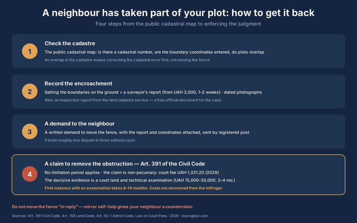
Step 1. Check what the cadastre actually records
The first thing a lawyer establishes in a boundary case is not where the fence stands but what the State Land Cadastre records. Open the Public Cadastral Map and check three things: whether your plot has a cadastral number, whether the coordinates of the boundary turning points are entered, and whether the neighbour’s plot already overlaps yours in the register itself. A cadastre extract is issued within three working days, and an electronic one the same day.
The answer shapes the whole strategy:
- the boundaries are in the cadastre and the neighbour has simply moved the fence — the simplest case, a dispute about actual use;
- the boundaries overlap in the cadastre — a dispute about an error in the documentation, and one side’s papers will have to be corrected;
- the plot has no cadastral number and rests on 1990s documentation — land management and registration under Article 79-1 of the Land Code come first, the boundary dispute second.
Step 2. Document the infringement
“He took half a metre” is not something a court can work with. Documents are:
- A cadastral survey and a record of setting the boundaries out on the ground — a certified surveyor places the boundary markers according to the cadastre coordinates and draws up a record. If the neighbour’s fence turns out to be beyond those markers on your side, that is the key evidence. The cost is roughly 3,000–6,000 UAH and it takes 1–2 weeks.
- Photographs tied to the boundary markers and dated, ideally with a visible tape measure or geotag.
- An approach to the Geocadastre. The inspectorate draws up a report on compliance with land legislation and issues a notice to the offender. It is free, applications are dealt with within 30 days, and the case gains an official document, though the notice does not itself return the land.
Step 3. Try to settle it out of court
A written demand enclosing the boundary record and requiring the fence to be moved by a stated date closes a good share of these conflicts: once a person sees the coordinates and the surveyor’s signature, there is nothing left to argue about. Send it by registered post with an inventory of the contents and allow a reasonable period, usually 14–30 days.
Boundary disputes inside settlements may also be heard by the local council (Article 158 of the Land Code). The council decides within a month, but its decision is not enforceable, so this stage is useful more as an extra document and as pressure before court. The good-neighbour rules relied on in negotiations are in Articles 103–109 of the Land Code.
Step 4. The claim in court
The main tool is a claim to remove obstacles to the use of your plot under Article 391 of the Civil Code: to demolish or move the fence, to vacate the part taken without authority, to bring the boundary into line with the cadastre. Two features are worth knowing in advance:
- limitation does not apply, because the infringement is continuing, so the objection “you are three years too late” does not work here even if the fence has stood since 2015;
- the claim is non-monetary, so the court fee is fixed — 1,331.20 UAH in 2026, that is 0.4 of the subsistence minimum, not a percentage of the value of the land. Filing through the Electronic Court reduces it by 20 %, to 1,064.96 UAH.
If the neighbour has managed to register title to the disputed strip, or the boundaries overlap in the cadastre, the claim also seeks to have the land management documentation declared invalid and the registration cancelled. The case becomes more complex but remains winnable on precise evidence; in some cases a claim to establish title to the disputed part is brought alongside.
The court land survey report: the decisive evidence
In contested cases the court orders a land survey report: the expert overlays the actual boundaries on the cadastre coordinates and both sides’ documentation and states who has strayed onto whose land and by how much. In practice that report decides the case. It costs roughly 15,000–30,000 UAH and is usually paid for by the claimant, with the cost recovered from the defendant on a win under Article 141 of the Civil Procedure Code. It takes 2–4 months, and with the first-instance hearing a boundary case runs 8–14 months.

Four encroachment scenarios and what to prove in each
| Scenario | What to prove | Main claim | Time and cost |
|---|---|---|---|
| Boundaries in the cadastre, fence moved | the actual boundary differs from the coordinates | removal of obstacles under Art. 391 CC | 4–6 months, fee 1,331.20 UAH |
| Overlapping plots in the cadastre itself | one side’s documentation is wrong | declaring the documentation invalid and correcting the cadastre | 8–14 months, expert report 15,000–30,000 UAH |
| The neighbour has registered title to the strip | your documentation came first | cancelling the registration plus the removal claim | 10–18 months with an appeal |
| Your plot has no cadastral number | your right of use under the old documents | form the plot under Art. 79-1 first, then litigate | +2–4 months before the case starts |
What to do in the first 30 days
- Days 1–3: check the Public Cadastral Map and order an extract from the State Land Cadastre and an information certificate from the Register of Real Property Rights for both plots.
- Days 3–14: commission a certified surveyor to set the boundaries out on the ground, invite the neighbour to attend in writing, and record the result formally.
- Days 14–16: send the demand by registered post with a copy of the record and 14–30 days to move the fence.
- Days 16–20: apply to the Geocadastre for an inspection of compliance with land legislation; it has 30 days to respond.
- Day 30 onwards: if there is no response, prepare the claim, applying at the same time for interim relief so that the neighbour does not put up a permanent structure on the disputed strip.
Owners’ typical mistakes
- Moving the fence yourself “in reply”. That is self-help in mirror image: the neighbour will counterclaim, and “I was restoring justice” will not help you in court.
- Litigating without the boundaries set out on the ground. Without a record of the coordinates the claim rests on assertion, and the court will dismiss it as unproved.
- Ignoring an error in the cadastre. If the overlap exists in the register itself, a demand to “move the fence” achieves nothing until the documentation is corrected.
- Missing the moment the neighbour registers title to the disputed strip. Stopping the registration with objections is cheaper than having it cancelled in court later.
- Seeking to “punish” rather than to “recover”. The fine for unauthorised occupation of land under Article 53-1 of the Code of Administrative Offences is 10 to 50 tax-free minimums for individuals, that is 170–850 UAH, and it does not return the land.
When you do not need a lawyer
If the boundaries are in the cadastre, the record is unambiguous and the neighbour moves the fence after your demand, you can manage alone: a surveyor plus a registered letter. Nor is representation needed where both sides agree to correct the boundary and only the new documentation has to be settled. A lawyer becomes essential when the neighbour ignores the documents, when the boundaries overlap in the cadastre, when a permanent structure already stands on the disputed strip, when title to it has been registered, or when the dispute moves into court representation with expert evidence.
Questions and answers
My neighbour has put a fence on my land. Where do I start?
By checking the Public Cadastral Map and commissioning a certified surveyor to set the boundaries out on the ground. The record with the coordinates is the basic document both for the demand and for court.
The fence has stood for more than ten years. Can I still do anything?
Yes. No limitation period applies to a claim under Article 391 of the Civil Code, because the infringement is continuing. Length of use does not make your neighbour the owner of your strip.
What does recovering an encroached strip through the courts cost?
The costs have three parts: the court fee on a non-monetary claim, 1,331.20 UAH in 2026; the land survey report, 15,000–30,000 UAH; and setting the boundaries out on the ground, 3,000–6,000 UAH. If you win, these sums are recovered from the defendant.
What does setting the boundaries out on the ground mean, and who does it?
It means placing boundary markers on the site according to the coordinates in the State Land Cadastre. A certified surveyor carries it out and records the result formally. Without that procedure an encroachment is practically impossible to prove.
Can the village council resolve a boundary dispute?
Local authorities do hear boundary disputes inside settlements under Article 158 of the Land Code, but their decisions are not enforceable. If the neighbour disagrees, only a court settles it.
Our plots overlap in the cadastre itself. Whose fault is that?
It is an error in the documentation, usually the result of an imprecise survey in an earlier land management project. It is corrected through the courts: part of the documentation is declared invalid and the cadastre amended. Which side’s documentation is wrong is determined by the land survey report.
The neighbour has registered title to the disputed strip. Is everything lost?
No, but the case becomes harder: cancellation of the registration and a declaration that the documentation is invalid are added to the removal claim. Such cases are won where your documentation came first and is accurate.
What is the fine for occupying land without authority?
Under Article 53-1 of the Code of Administrative Offences individuals face 10 to 50 tax-free minimums, that is 170–850 UAH. Where the occupation caused substantial damage (a hundred or more tax-free minimums within the meaning of the note to Article 197-1 of the Criminal Code, roughly 166,400 UAH in 2026), criminal liability arises.
How long does a boundary case take in court?
With an expert report, 8–14 months at first instance. Without one, where the encroachment is obvious from the cadastre, 4–6 months. An appeal adds another 3–6 months.
My plot has no cadastral number. Can I still sue?
You will first have to prepare the technical documentation and register the plot in the cadastre, since without defined coordinates the court has nothing to compare the actual boundaries with. That adds 2–4 months, but without it the case has no prospect. The registration procedure is described on the page about privatising a plot of land.
Sources
- Civil Code of Ukraine, Art. 391 — zakon.rada.gov.ua/laws/show/435-15
- Land Code of Ukraine, Arts. 79-1, 103–109, 152, 158 — zakon.rada.gov.ua/laws/show/2768-14
- Law of Ukraine “On the State Land Cadastre” No. 3613-VI — zakon.rada.gov.ua/laws/show/3613-17
- Code of Administrative Offences, Art. 53-1; Criminal Code of Ukraine, Art. 197-1 — zakon.rada.gov.ua/laws/show/8073-10
- Law of Ukraine “On Court Fees” No. 3674-VI — zakon.rada.gov.ua/laws/show/3674-17
Recovering encroached land with Svarog
Send us the cadastral number of the plot and a photograph of the disputed boundary — we will check the cadastre data, arrange for the boundaries to be set out on the ground, and start with a demand, which often closes the conflict without court. If court is unavoidable, we run the case through the expert report to enforcement of the judgment. Related services: land lawyer, court representation, full price list.
+38 095 554-54-24 · Kyiv, 7 Khoriva Street (Podil) · Mon–Fri 9.00–18.00